


Home | About | Historical Marker Program
Location: on OK-96 in Burneyville
Topics: Education; Territorial Period, 1861–1907
The school, once known as Red River School, was a subscription school when it was founded in 1880s. It closed in 1957.
Location: on OK-32, 3 1/4 miles east of Jefferson County line
Topics: Early Statehood, 1907–1941; Education; Settlement Patterns
Originally serving students in the town of Courtney, the school closed in 1928 when the county border changed and several small schools were consolidated.
Location: on OK-32 at Ennville
Coordinates: 33.981711, -96.987312
Material: Aluminum
Sponsor(s): Keel Cemetery Association and Oklahoma Historical Society
Topics: American Indians; Government; Settlement Patterns; Westward Expansion, 1803–1861
Born in Mississippi, Pickens was the first elected chief of the Chickasaw Nation after it was forcibly removed to Indian Territory in 1837. Pickens County in the Chickasaw Nation was named for him. Signed the treaty of alliance between the Chickasaw and Choctaw Nations and the Confederacy in July 1861. Signed treaties with the US government in 1852, 1855, and 1866.
Location: at Leon Baptist Church in Leon (OBHC)
Topics: American Indians; Religion/Philosophy; Territorial Period, 1861–1907
In August 1885, the Enon Baptist Association was founded at Wilson Creek Church in the Chickasaw Nation.
Location: at Love County Courthouse, 405 W Main St, in Marietta
Coordinates: 33.937225, -97.120806
Material: Granite
Sponsor(s): Love County Leadership Class IV/Oklahoma Centennial Commission
Topics: Agriculture; American Indians; Indian and Frontier Trade; Territorial Period, 1861–1907
Love County has a rich historical significance to Oklahoma and the nation. Carved from the Louisiana Purchase and acquired from the Choctaw Nation by the Chickasaw Nation, the county was named for the Loves, a prominent Chickasaw family. Early settlers influenced how the frontier area would be shaped. The area supported early-day commerce, numerous ferry crossings, and some of the first trading posts in the Indian Territory. Cattle ranchers, such as Bill Washington, controlled large Indian land holdings. The Arbuckle Trail, near Overbrook, was laid out by Jesse Chisholm of Chisholm Trail fame. Cotton was the major crop grown from the late 1800s to the mid 1900s, contributing to the greatest inland cotton market in the world.
Location: on OK-32 (W Main St) at Love County Courthouse in Marietta
Coordinates: 33.937350, -97.121033
Material: Aluminum
Sponsor(s): Marietta Centennial Committee and Oklahoma Historical Society
Topics: Early Statehood, 1907–1941; Government
Oklahoma’s first county courthouse built after statehood. The cornerstone was laid on April 28, 1910, and was dedicated on November 24. The building houses all county offices and is a point of pride and focus of community events.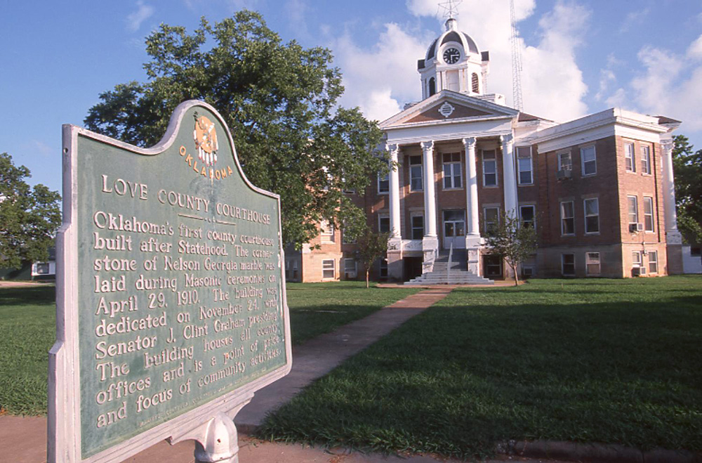
Location: on county road, three miles north and three miles west of Marietta
Topics: Early Statehood, 1907–1941; Education; Industrial Period, 1841–1892
This community school served area children from 1930 to 1958. It was created when schools from the Bowles, Eastman, Marsden, and New Hope districts were consolidated.
Location: on OK-76, 17 miles west and nine miles north of Marietta
Topics: Early Statehood, 1907–1941; Education; Industrial Period, 1841–1892
The Post Oak school existed from 1916 to 1950 and was part of a joint district that served students in Love and Carter Counties.
(Page 1 of 1)
Historical Marker Program
Search Results
Your search returned 8 results.
Burneyville School
Love CountyLocation: on OK-96 in Burneyville
Topics: Education; Territorial Period, 1861–1907
The school, once known as Red River School, was a subscription school when it was founded in 1880s. It closed in 1957.
Courtney School
Love CountyLocation: on OK-32, 3 1/4 miles east of Jefferson County line
Topics: Early Statehood, 1907–1941; Education; Settlement Patterns
Originally serving students in the town of Courtney, the school closed in 1928 when the county border changed and several small schools were consolidated.
Edmund Pickens (Ok-chan-tubby)
Love CountyLocation: on OK-32 at Ennville
Coordinates: 33.981711, -96.987312
Material: Aluminum
Sponsor(s): Keel Cemetery Association and Oklahoma Historical Society
Topics: American Indians; Government; Settlement Patterns; Westward Expansion, 1803–1861
Born in Mississippi, Pickens was the first elected chief of the Chickasaw Nation after it was forcibly removed to Indian Territory in 1837. Pickens County in the Chickasaw Nation was named for him. Signed the treaty of alliance between the Chickasaw and Choctaw Nations and the Confederacy in July 1861. Signed treaties with the US government in 1852, 1855, and 1866.
Enon Baptist Association
Love CountyLocation: at Leon Baptist Church in Leon (OBHC)
Topics: American Indians; Religion/Philosophy; Territorial Period, 1861–1907
In August 1885, the Enon Baptist Association was founded at Wilson Creek Church in the Chickasaw Nation.
Love County
Love CountyLocation: at Love County Courthouse, 405 W Main St, in Marietta
Coordinates: 33.937225, -97.120806
Material: Granite
Sponsor(s): Love County Leadership Class IV/Oklahoma Centennial Commission
Topics: Agriculture; American Indians; Indian and Frontier Trade; Territorial Period, 1861–1907
Love County has a rich historical significance to Oklahoma and the nation. Carved from the Louisiana Purchase and acquired from the Choctaw Nation by the Chickasaw Nation, the county was named for the Loves, a prominent Chickasaw family. Early settlers influenced how the frontier area would be shaped. The area supported early-day commerce, numerous ferry crossings, and some of the first trading posts in the Indian Territory. Cattle ranchers, such as Bill Washington, controlled large Indian land holdings. The Arbuckle Trail, near Overbrook, was laid out by Jesse Chisholm of Chisholm Trail fame. Cotton was the major crop grown from the late 1800s to the mid 1900s, contributing to the greatest inland cotton market in the world.
Love County Courthouse
Love CountyLocation: on OK-32 (W Main St) at Love County Courthouse in Marietta
Coordinates: 33.937350, -97.121033
Material: Aluminum
Sponsor(s): Marietta Centennial Committee and Oklahoma Historical Society
Topics: Early Statehood, 1907–1941; Government
Oklahoma’s first county courthouse built after statehood. The cornerstone was laid on April 28, 1910, and was dedicated on November 24. The building houses all county offices and is a point of pride and focus of community events.
Meadowbrook School
Love CountyLocation: on county road, three miles north and three miles west of Marietta
Topics: Early Statehood, 1907–1941; Education; Industrial Period, 1841–1892
This community school served area children from 1930 to 1958. It was created when schools from the Bowles, Eastman, Marsden, and New Hope districts were consolidated.
Post Oak School
Love CountyLocation: on OK-76, 17 miles west and nine miles north of Marietta
Topics: Early Statehood, 1907–1941; Education; Industrial Period, 1841–1892
The Post Oak school existed from 1916 to 1950 and was part of a joint district that served students in Love and Carter Counties.
(Page 1 of 1)
Marker Search
Browse by County
Adair County
Alfalfa County
Atoka County
Beaver County
Beckham County
Blaine County
Bryan County
Caddo County
Canadian County
Carter County
Cherokee County
Choctaw County
Cimarron County
Cleveland County
Comanche County
Cotton County
Craig County
Creek County
Custer County
Delaware County
Dewey County
Ellis County
Garfield County
Garvin County
Grady County
Grant County
Greer County
Harmon County
Harper County
Haskell County
Hughes County
Jackson County
Jefferson County
Johnston County
Kay County
Kingfisher County
Kiowa County
Latimer County
Le Flore County
Lincoln County
Logan County
Love County
Major County
Marshall County
Mayes County
McClain County
McCurtain County
McIntosh County
Murray County
Muskogee County
Noble County
Okfuskee County
Oklahoma County
Okmulgee County
Osage County
Ottawa County
Pawnee County
Payne County
Pittsburg County
Pontotoc County
Pottawatomie County
Pushmataha County
Roger Mills County
Rogers County
Seminole County
Sequoyah County
Stephens County
Texas County
Tillman County
Tulsa County
Wagoner County
Washington County
Washita County
Woods County
Woodward County
To find out more about the Oklahoma Historical Society Historical Marker Program or how to submit an application, please visit the Historical Marker Program page.
Missing or Damaged Markers
Please use our online form to report missing or damaged historical markers.
Report Missing or Damaged Markers
Contact Us
If you have questions, please contact:
Matthew Pearce
Oklahoma Historical Society
800 Nazih Zuhdi Drive
Oklahoma City, OK 73105
405-522-8659
[email protected]