


Home | About | Historical Marker Program
Location: on US-183/US-412, one mile east of Fort Supply
Coordinates: 36.567624, -99.553785
Material: Aluminum
Sponsor(s): Oklahoma Historical Society and the Oklahoma Department of Transportation
Topics: Military; Territorial Period, 1861–1907
Established in 1868, Camp Supply served as a forward base for Col. George Armstrong Custer’s 7th Cavalry. The post was designated Fort Supply in 1878 and abandoned in 1894.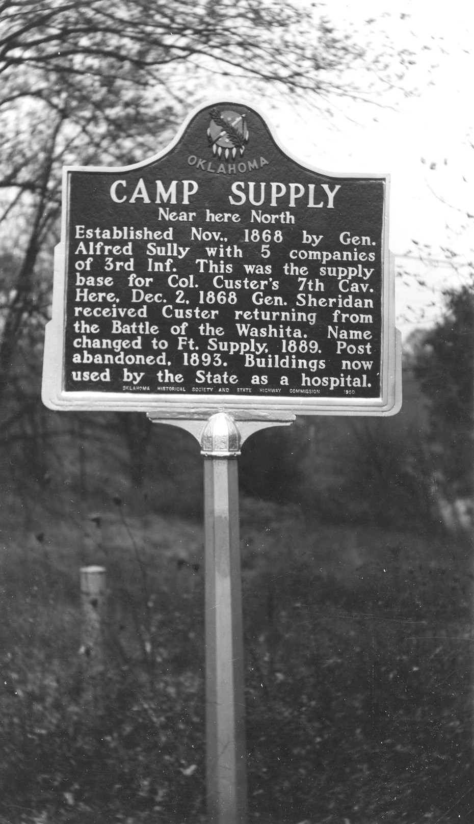

Location: in Boiling Springs State Park
Material: Granite
Topics: Early Statehood, 1907–1941; Environmental/Cultural Ecology; Government; Recreation/Service; Social/Cultural
Company 2822 of the Civilian Conservation Corps (CCC) built the Boiling Springs State Park from 1935 to 1940 as part of the federal government's program to provide jobs during the Great Depression.
Location: Fort Supply
Sponsor(s): Leland Bement
Topics: American Indians; Environmental/Cultural; Pre-European Contact, before 1541 AD; Recreational/Service; Social/Cultural
Two miles northeast of here is the Cooper Paleo-Indian bison kill site. The site was the scene of three of the largest Folsom (ca. 10,500 years ago) bison kills known. Each event saw more than thirty bison herded into a dead-end gully. Hunters on the gully rim killed the animals with spears tipped with finely crafted Folsom points. A bison skull beneath the second kill was painted with red zigzag lines to ensure a successful hunt. The mineral pigment was red hematite. This is the oldest painted skull in North America and is the earliest evidence of hunting ritual for the Plains region.
Location: Ninth Street (OK-34) and Jefferson Avenue in Woodward
Coordinates: 36.442806, -99.390556
Material: Other (Stone pedestal)
Sponsor(s): Unknown
Topics: Indian and Frontier Trade; Military; Territorial Period, 1961–1907; Transportation
A supply road was established between Fort Supply and the Cheyenne-Arapaho Agency in Darlington in 1870. The road was an extension of the Fort Dodge (KS)–Fort Supply road and extended to Fort Reno in 1875. The road provided an important transportation route before the construction of railroads.
Note: This marker no longer exists (removed c. 2023). It was identical to the Fort Supply – Fort Reno Military Road marker south of Moorland on OK-50.
Location: on OK-50, one mile west and two miles south of Mooreland
Coordinates: 36.399288, -99.228755
Material: Other (Stone pedestal)
Sponsor(s): Moorland Lions Club
Topics: Indian and Frontier Trade; Military; Territorial Period, 1861–1907; Transportation
A supply road was established between Fort Supply and the Cheyenne-Arapaho Agency in Darlington in 1870. The road was an extension of the Fort Dodge – Fort Supply road and extended to Fort Reno in 1875. The road provided an important transportation route before the construction of railroads.
Location: at St. John's Episcopal Church at Tenth and Texas Streets in Woodward
Sponsor(s): Daughters of the American Revolution
Topics: Military; Religion/Philosophy; Retail; Territorial Period, 1861–1907; Transportation
Once considered to have been a military chapel at Fort Supply, the building was never located at the fort and actually was constructed sometime after 1888 in Woodward. A local businessman later had the building moved to its present location to accommodate a shorter walking distance for his wife.
Location: on US-270, one mile west of Fort Supply
Coordinates: 36.578908, -99.591265
Material: Aluminum
Sponsor(s): Daughters of the American Revolution and the Oklahoma Historical Society
Topics: Indian and Frontier Trade; Military; Social/Cultural; Territorial Period, 1861–190; Transportation
Here, between 1874 and 1890, supply wagons, a daily stagecoach, and the US mail moved over this earliest known trail from Dodge City, Kansas to Fort Elliott, Texas. Fort Elliot, first known as “Cantonment on the Sweetwater” was established in the Texas Panhandle after the Kiowa, Comanche and Cheyenne attack on Adobe Walls in June 1874.
Note: This site originally featured a small granite marker in addition to the aluminum marker. The granite marker no longer exists.

Location: Ninth Street (OK-34) and Main Street in Woodward
Coordinates: 36.436072, -99.390562
Material: Aluminum
Sponsor(s): City of Woodward
Topics: Law and Order; Territorial Period, 1861–1907
A native Texan, Temple Lea Houston arrived in Woodward in 1893. He practiced law, spoke to rapt audiences, participated in a gunfight with the Jennings borthers, and was tried and acquitted for manslaughter in the shooting death of Ed Jennings. He died in 1905 and is buried in Woodward.
(Page 1 of 1)
Historical Marker Program
Search Results
Your search returned 8 results.
Camp Supply
Woodward CountyLocation: on US-183/US-412, one mile east of Fort Supply
Coordinates: 36.567624, -99.553785
Material: Aluminum
Sponsor(s): Oklahoma Historical Society and the Oklahoma Department of Transportation
Topics: Military; Territorial Period, 1861–1907
Established in 1868, Camp Supply served as a forward base for Col. George Armstrong Custer’s 7th Cavalry. The post was designated Fort Supply in 1878 and abandoned in 1894.
Civilian Conservation Corps and Boiling Springs State Park
Woodward CountyLocation: in Boiling Springs State Park
Material: Granite
Topics: Early Statehood, 1907–1941; Environmental/Cultural Ecology; Government; Recreation/Service; Social/Cultural
Company 2822 of the Civilian Conservation Corps (CCC) built the Boiling Springs State Park from 1935 to 1940 as part of the federal government's program to provide jobs during the Great Depression.
The Cooper Site
Woodward CountyLocation: Fort Supply
Sponsor(s): Leland Bement
Topics: American Indians; Environmental/Cultural; Pre-European Contact, before 1541 AD; Recreational/Service; Social/Cultural
Two miles northeast of here is the Cooper Paleo-Indian bison kill site. The site was the scene of three of the largest Folsom (ca. 10,500 years ago) bison kills known. Each event saw more than thirty bison herded into a dead-end gully. Hunters on the gully rim killed the animals with spears tipped with finely crafted Folsom points. A bison skull beneath the second kill was painted with red zigzag lines to ensure a successful hunt. The mineral pigment was red hematite. This is the oldest painted skull in North America and is the earliest evidence of hunting ritual for the Plains region.
Fort Supply – Fort Reno Military Road
Woodward CountyLocation: Ninth Street (OK-34) and Jefferson Avenue in Woodward
Coordinates: 36.442806, -99.390556
Material: Other (Stone pedestal)
Sponsor(s): Unknown
Topics: Indian and Frontier Trade; Military; Territorial Period, 1961–1907; Transportation
A supply road was established between Fort Supply and the Cheyenne-Arapaho Agency in Darlington in 1870. The road was an extension of the Fort Dodge (KS)–Fort Supply road and extended to Fort Reno in 1875. The road provided an important transportation route before the construction of railroads.
Note: This marker no longer exists (removed c. 2023). It was identical to the Fort Supply – Fort Reno Military Road marker south of Moorland on OK-50.
Fort Supply – Fort Reno Military Road
Woodward CountyLocation: on OK-50, one mile west and two miles south of Mooreland
Coordinates: 36.399288, -99.228755
Material: Other (Stone pedestal)
Sponsor(s): Moorland Lions Club
Topics: Indian and Frontier Trade; Military; Territorial Period, 1861–1907; Transportation
A supply road was established between Fort Supply and the Cheyenne-Arapaho Agency in Darlington in 1870. The road was an extension of the Fort Dodge – Fort Supply road and extended to Fort Reno in 1875. The road provided an important transportation route before the construction of railroads.
Military Chapel
Woodward CountyLocation: at St. John's Episcopal Church at Tenth and Texas Streets in Woodward
Sponsor(s): Daughters of the American Revolution
Topics: Military; Religion/Philosophy; Retail; Territorial Period, 1861–1907; Transportation
Once considered to have been a military chapel at Fort Supply, the building was never located at the fort and actually was constructed sometime after 1888 in Woodward. A local businessman later had the building moved to its present location to accommodate a shorter walking distance for his wife.
Military Road Crossing
Woodward CountyLocation: on US-270, one mile west of Fort Supply
Coordinates: 36.578908, -99.591265
Material: Aluminum
Sponsor(s): Daughters of the American Revolution and the Oklahoma Historical Society
Topics: Indian and Frontier Trade; Military; Social/Cultural; Territorial Period, 1861–190; Transportation
Here, between 1874 and 1890, supply wagons, a daily stagecoach, and the US mail moved over this earliest known trail from Dodge City, Kansas to Fort Elliott, Texas. Fort Elliot, first known as “Cantonment on the Sweetwater” was established in the Texas Panhandle after the Kiowa, Comanche and Cheyenne attack on Adobe Walls in June 1874.
Note: This site originally featured a small granite marker in addition to the aluminum marker. The granite marker no longer exists.
Temple Lea Houston
Woodward CountyLocation: Ninth Street (OK-34) and Main Street in Woodward
Coordinates: 36.436072, -99.390562
Material: Aluminum
Sponsor(s): City of Woodward
Topics: Law and Order; Territorial Period, 1861–1907
A native Texan, Temple Lea Houston arrived in Woodward in 1893. He practiced law, spoke to rapt audiences, participated in a gunfight with the Jennings borthers, and was tried and acquitted for manslaughter in the shooting death of Ed Jennings. He died in 1905 and is buried in Woodward.
(Page 1 of 1)
Marker Search
Use quotation marks to search for an exact phrase.
Browse by County
Adair County
Alfalfa County
Atoka County
Beaver County
Beckham County
Blaine County
Bryan County
Caddo County
Canadian County
Carter County
Cherokee County
Choctaw County
Cimarron County
Cleveland County
Comanche County
Cotton County
Craig County
Creek County
Custer County
Delaware County
Dewey County
Ellis County
Garfield County
Garvin County
Grady County
Grant County
Greer County
Harmon County
Harper County
Haskell County
Hughes County
Jackson County
Jefferson County
Johnston County
Kay County
Kingfisher County
Kiowa County
Latimer County
Le Flore County
Lincoln County
Logan County
Love County
Major County
Marshall County
Mayes County
McClain County
McCurtain County
McIntosh County
Murray County
Muskogee County
Noble County
Nowata County
Okfuskee County
Oklahoma County
Okmulgee County
Osage County
Ottawa County
Pawnee County
Payne County
Pittsburg County
Pontotoc County
Pottawatomie County
Pushmataha County
Roger Mills County
Rogers County
Seminole County
Sequoyah County
Stephens County
Texas County
Tillman County
Tulsa County
Wagoner County
Washington County
Washita County
Woods County
Woodward County
To find out more about the Oklahoma Historical Society Historical Marker Program or how to submit an application, please visit the Historical Marker Program page.
Missing or Damaged Markers
Please use our online form to report missing or damaged historical markers.
Report Missing or Damaged Markers
Contact Us
If you have questions, please contact:
Matthew Pearce
Oklahoma Historical Society
800 Nazih Zuhdi Drive
Oklahoma City, OK 73105
405-522-8659
[email protected]